Madinah Beyond an Hour on Foot
Figure · 19 September 2026 edition
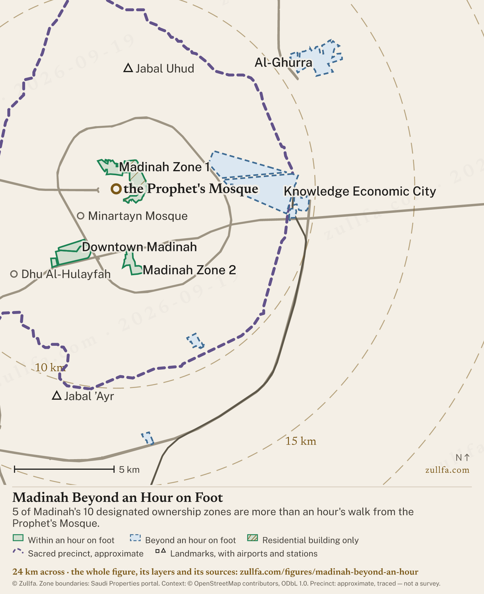
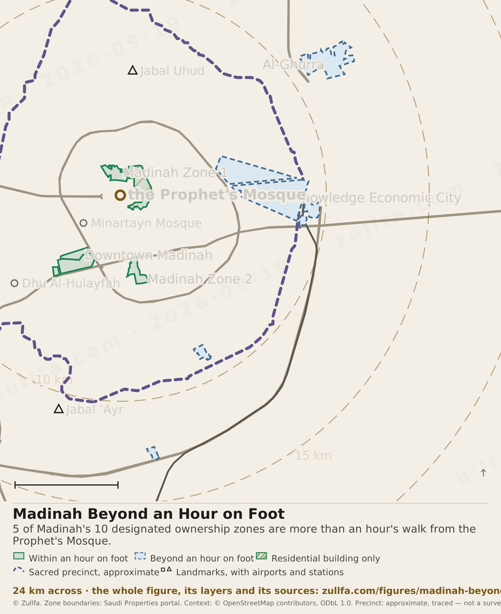
5 of Madinah's 10 designated ownership zones are more than an hour's walk from the Prophet's Mosque. Walking time here is a minimum: the straight line from a zone's nearest boundary point to the Prophet's Mosque, walked at 1.2 metres a second. Streets only add distance, so a zone that misses a band here cannot make it on foot.
Updated 19 September 2026
Madinah, north up, with 10 designated zones drawn. You can zoom in. The table below the figure lists every zone.
Interactive map. With the map focused: arrow keys move it, plus and minus zoom, zero returns to the opening view. The zoom buttons are in the map’s top corner. “Layers”, under the map, switches each layer on or off and holds the views and the buttons that move the map, so everything dragging does can be done without it.
Drag to move, scroll to zoom
Madinah Beyond an Hour on Foot · 5 zones, drawn on their published boundaries2026-09-19 edition
- Within an hour on foot
- Beyond an hour on foot
- Residential building only
- Sacred precinct, approximate
View
- Landmarks, with airports and stations
- Rings: minutes, then kilometres
- the Prophet's Mosque
Walking time here is a minimum: the straight line from a zone's nearest boundary point to the Prophet's Mosque, walked at 1.2 metres a second. Streets only add distance, so a zone that misses a band here cannot make it on foot.
Zone boundaries published by the Saudi Properties portal, retrieved 19 Sep 2026, simplified to 10 m for drawing; distances are measured on the full boundary, and the rings are straight-line distance at 1.2 m/s, a floor on the walk. Sacred precinct: approximate, traced from a published boundary map and georeferenced against the road network; not a survey.
Boundaries: Saudi Properties portal, 19 Sep 2026. Map data © OpenStreetMap contributors, ODbL 1.0. Drawing © Zullfa.
The figure’s data as a table
| Zone | Register code | On the register | Area | Nearest edge | Farthest edge | On foot, at least | What may be built |
|---|---|---|---|---|---|---|---|
| Rua Al-Madinah | L048 | Rua Al Madinah · رؤى المدينة | 1.4 km² | 650 m | 1.8 km | 10–11 min | Residential building only |
| Madinah Zone 1 | L354 | Al-Madinah Al-Munawwarah – Zone (1) · المدينة المنورة – منطقة (1) | 59 ha | 710 m | 1.7 km | 10–12 min | All six property uses |
| Downtown Madinah | L200 | Downtown Madinah · داون تاون المدينة | 41 ha | 3.0 km | 4.2 km | 42–51 min | All six property uses |
| Madinah Zone 2 | L300 | Al-Madinah Al-Munawwarah – Zone (2) · المدينة المنورة – منطقة (2) | 58 ha | 3.1 km | 4.4 km | 44–53 min | All six property uses |
| Darat Al-Hijra | L011 | Dar Al Hijrah · دار الهجرة | 1.1 km² | 3.2 km | 5.1 km | 44–53 min | All six property uses |
| Knowledge Economic City | L023 | Knowledge Economic City · مدينة المعرفة الاقتصادية | 6.8 km² | 4.8 km | 9.2 km | Beyond walking distance | All six property uses |
| Al-Mahwa | L316 | Al-Mahwa · المهوى | 30 ha | 8.3 km | 9.1 km | Beyond walking distance | All six property uses |
| Mishraf | L211 | Mishraf · مشراف | 47 ha | 8.9 km | 9.7 km | Beyond walking distance | All six property uses |
| Al-Ghurra | L311 | Al-Ghurrah · الغرة | 2.4 km² | 10.8 km | 13.3 km | Beyond walking distance | All six property uses |
| Diyar Al-Maqar | L312 | Diyar Al-Muqarr · ديار المقر | 19 ha | 12.4 km | 13.0 km | Beyond walking distance | All six property uses |
The sacred precinct is drawn on this figure as a line, for orientation. No surveyed boundary for the haram of Madinah is published as open data, so this outline is traced from a circulated boundary map and fitted to the road network. It is approximate, to roughly 200 m. Nothing on this site is measured from it, and it decides nothing about ownership: the precinct and the designated zones are two different lines. Where it matters where the boundary runs, the signs on the ground are the authority. Zone boundaries: Saudi Properties portal, retrieved 19 Sep 2026, simplified to 10 m for drawing. Roads, rail, stations, landmarks and precinct signage: © OpenStreetMap contributors, ODbL 1.0, retrieved 19 Sep 2026. Drawing © Zullfa, zullfa.com.
Which designated Madinah zones are too far to walk to Masjid an-Nabawi?
- Madinah zones beyond an hour on foot
- 5 of 10
- Which Madinah zones are beyond an hour
- Knowledge Economic City, Al-Mahwa, Mishraf, Al-Ghurra and Diyar Al-Maqar
Files
Four files, all the same figure. The image carries its own key, sources and address.
Citation
Madinah Beyond an Hour on Foot, Zullfa, 2026-09-19 edition. https://zullfa.com/figures/madinah-beyond-an-hour
The licence fits on one page.
About this figure
Or ask us, and our assistant answers from the same sources.
Where do these numbers come from?
From the full boundary the Saudi Properties portal publishes, retrieved 2026-09-19, measured from the point nearest the Prophet’s Mosque and walked at 1.2 and 1.0 metres a second, so each walk is a floor.
May I reuse this figure?
The measured data is published under CC BY 4.0, so you may reuse it anywhere, commercially too, with Zullfa named and linked. The drawing itself is ours, so embed it or use the PNG with the credit printed on it.
Sources
Saudi Properties portal — zone boundaries
Zone areas and distances on this site come from the boundaries the Saudi Properties portal publishes for each zone; a distance is the straight line from the nearest point of that boundary to the Grand Mosque or the Prophet's Mosque, so the walk is always longer.FHWA — Capacity Analysis of Pedestrian and Bicycle Facilities (FHWA-HRT-98-107) · 1 Feb 1998
The US Federal Highway Administration's pedestrian capacity study recommends a walking speed of 1.2 metres per second for most conditions, and 1.0 metres per second where more than a fifth of the people using a facility are aged 65 or over.Saudi Properties portal — zones · 23 Jun 2026
The official interactive map of designated zones is published on the Saudi Properties portal at saudiproperties.rega.gov.sa/zones.
Where each fact above comes from, with the source’s own date where it gives one.